Street naming and numbering policy
Version updates
The following is a record of the changes and updates that have occurred on this policy:
| Version | Changes or updates | Author | Date |
|---|---|---|---|
| 0.0 | Creation | D Cleary | - |
| 0.1 | Revision | A Anderson | 14/06/2011 |
| 0.2 | Revision | A Anderson | 07/09/2015 |
| 0.3 | Revision | A Anderson | 02/08/2017 |
| 0.4 | Revision | A Anderson | 20/05/2020 |
| 0.5 | Revision | A Anderson | 17/06/2020 |
| 0.6 | Revision | A Anderson | 12/09/2022 |
| 0.7 | Revision | A Anderson | 2023 |
| 0.8 | Revision – inclusion of LU Legislation | B Clayton | 2024 |
Street naming and numbering policy contents
The policy sets out the powers, policy and procedure for applying street naming and numbering within the area covered by Ashfield District Council.
It will provide consistent guidelines for dealing with any request for new addresses that is received by the Council.
1.1
The legislative position for street naming and numbering is complex, and various statutory provisions can apply. Under Schedule 14 of the Local Government Act 1972, paragraph 23, all provisions of the Public Health Acts 1875 to 1925 apply throughout England and Wales, subject to specified exceptions. The effect of this is that the legislation relating to numbering of houses is automatically applied.
1.2
However, paragraph 24 of Schedule 14 excludes from this automatic provision the legislation on street naming, the alteration of the name and marking of the name (i.e.. provision of street nameplates). It provides that where the relevant provisions apply in any area prior to 1 April 1974, those provisions will continue to apply.
1.3
Paragraph 25 of Schedule 14 then provides that for these street naming provisions, the Council has by resolution, resolved that the provisions shall apply throughout the area.
The relevant statutory provisions with regards to street naming are:
- Section 64 of the Town Improvement Clauses Act 1847 (incorporated into Section 160 of the Public Health Act 1875). This allows the Council to name streets (i.e. set names for the new streets), mark the street name (street nameplate provision) and control interference with such markings (under the legislation interference is a criminal offence).Section 81 of the Levelling Up and Regeneration Act 2023, Subsection (2) adds that a local authority within a district council in England may, by order, alter the name of a street, or any part of a street, in its area if the alteration has the necessary support.
- Section 81 of the Levelling Up and Regeneration Act 2023, Subsection (3), adds that 'where a local authority has altered the name of a street, or any part of a street, under subsection (2), it may cause the altered name to be painted or otherwise marked on a conspicuous part of any building or other erection.’ subsection (4) also adds that 'any person who then wilfully, and without the consent of the local authority, obliterates, defaces, obscures, removes or alters the altered name painted or otherwise marked under subsection (3) is liable to a penalty not exceeding level 1 on the standard scale.
- Section 17-19 of the Public Health Act 1925.
This legislation covers:
- new names of streets – notice served by developer and requiring the approval of the Council or (by appeal) the Magistrates’ Court (Section 17)
- The urban authority by order may assign a name to any street, or part of a street, to which a name has not been given. (Section 18).
- Marking of street names and control of interference – i.e. provision of street nameplates and prosecution of anyone removing or interfering with the nameplate (Section 19)
1.4
Section 18 of the Public Health Act 1925 enables an authority to alter the name of a street and to give a name to an un-named street (with the provision for an objector to require the decision to be considered and determined by the Magistrates’ Court. Although no consultation process is included in Section 18, officers would carry out a consultation in any event.
1.5
In terms of street numbering, these provisions are contained in Sections 64 and 65 of the Town Improvement Clauses Act 1847. These provisions allow the Council to designate numbers of individual houses in streets, ensure that all properties are properly marked with their number (or name), and control interference with such numbers. These provisions are automatically applied throughout England and Wales, via the Public Health Act 1875 and Schedule 14 of the Local Government Act 1972.
1.6
If Section 19 of the 1925 Act is adopted, the street naming provisions in the Town Improvement Clauses Act 1847 will cease to apply (and vice versa).
1.7
As well as simply determining the name or number to be allocated, the Council has (as part of dealing with these applications) carried out liaison services with other bodies. There is no statutory requirement for such liaison and consultation, but it is clearly related to the naming and numbering functions. As this is a discretionary service, a charge can be levied as set out in the Schedule of Charges on this website.
- link: Schedule of charges
1.8
The Local Government Act 2003 brought about new devolved powers for Local Authorities. These included giving Council new powers to charge for non-statutory (i.e. discretionary) services (Section 93 of the Act).
1.9
In 1994 a British Standard (BS7666 Spatial datasets for geographical referencing) was introduced. The standard comprises a number of parts covering Street Gazetteers, Land and Property Gazetteers and Delivery Points. BS7666 has been through a number of revisions with the last review taking place in 2005/2006. All addresses will be compliant with BS7666.
1. Definition
Ashfield District Council has a statutory duty to name and number streets and to approve and register official property addresses within its council boundary. This function is outlined in this document.
2. Aim and purpose
The main purpose of this policy is to ensure all properties located within Ashfield are assigned with a consistent postal address. This includes both new and converted properties, large developments and single in-fill plots, residential and commercial buildings, as well as properties which may not have had official addresses assigned in the past.
Having consistent and logical addresses will ensure that properties are easily located by the Council, the emergency services and other organisations, allowing for quick and efficient delivery goods and services to the property.
3. Scope
This policy will affect Ashfield Council staff, Ashfield residents and external organisation. All properties located within the Ashfield District Council boundary are required to be addressed according to this policy.
4. Service delivery
The GIS Technician is responsible for address management service delivery. The post holder sits within the Corporate Policy and Improvement Unit section of the Transformation Directorate.
The GIS Technician is also the LLPG Custodian and the SNN Officer for Ashfield District Council.
The GIS Technician reports to the Corporate Information Analyst and handles the day-to-day administration of the Street Naming and Numbering function.
Requests for new street names are completed within 3 months and requests for new street numbering are completed within 7 days.
5. Charges for street naming and numbering service
Our current schedule of charges can be found on this website:
- link: Fees and charges
6. Monitoring and review
This policy document will be reviewed every three years, or if a major change in the process is required (because of new legislation for example). Charges will be reviewed on an annual basis, usually for 1 April.
All complaints will be reviewed as they are received in line with the Council’s complaints procedure with any required changes to the process being implemented as soon as possible.
7. Sustainability, equality and regeneration
Our process does not discriminate against any person or company. All requests are actioned as soon as they are received and the required payment is made.
8. Contact details
- link: Street naming and numbering
- email: lpg@ashfield.gov.uk
- telephone: 01623 457 281
- address:
Ashfield District Council
Urban Road
Kirkby in Ashfield
Nottingham
NG17 8DA
The street numbering function is carried out by the GIS (Geographic Information Services) Team. The following procedure has been devised in collaboration with the Building Control Section and the Committee Clerks section to clarify street numbering and ensure that consistency is attained when dealing with either infill, new developments or renumbering schemes.
The prime purpose of this function of Local Authorities is to facilitate easy identification of premises by, amongst others, the emergency services.
GeoPlace has released the Street naming and numbering code of practice, which contains guidance for officers. This will form the basis of our procedure and will be followed where possible.
1. New naming and numbering requests
In the case of major developments, once the developer has commenced building on site a plan will be passed to the Street Numbering Officer, either by an internal department, such as Building Control or Legal Section, or direct from the developer.
For a minor development, single plot or an infill plot the request can come from the Building Control Inspector or direct from the developer, and their recommendations or details of the site location will be passed to the duty Street Numbering Officer.
The developer’s plan must include:
- Total number of plots
- Proposed street name(s)
- Types of property: flats including number of storeys and flats per storey
- Door access to street
- Site boundary
- Access road and name
- North arrow
- Plot numbers
The Street Numbering Officer will then review the plan and if necessary carry out a site visit to assess the development. If required contact the Developer to resolve any issues.
2. Payments
The Street Numbering Officer will calculate the charge, where applicable, for each request and obtain agreement in writing (by email) from the developer/requestor.
Payments can be made easily online via our website e-store. Other payment options are available such as over the telephone using a debit or credit card, or direct payments can also be made via BACS.
If required, an invoice can be raised against the relevant cost code and sent by post or email for payment. Once payment is received the request can be progressed.
3. Assigning street names
Requests for new street names are carried out in consultation with the, emergency services, Royal Mail and Local Councillors. Local Councillors are engaged early in the process in conjunction with the developer. Once agreed, site notices are put on site for 4 weeks before confirming. This process takes 3 months but notification is not released until payment has been received. The Council, as the Street Naming and Numbering Authority, has the final say on the names proposed.
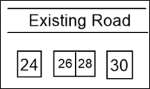
- Street names are not necessarily required where there is sufficient numbering available along an existing road.
- Street names are not necessarily required where the new properties exist on a private driveway or access and the road does not have curbs and separate road markings.
- Street names are not necessarily required for developments of less than 10 properties.
- Street names are not necessarily required where the roadway is not intended for adoption by Nottinghamshire County Council.
Each case will be reviewed individually, and a decision made on whether a street name is required.
4. Assigning addresses (no charge applied)
The Street Numbering Officer will then prepare a site plan using the developer’s plan. Make a copy of the Developer plan to create draft numbering scheme.
Mark out on draft plan the proposed naming and numbering scheme.
Highlight each different road in a different colour and number all properties on that road in the same colour. To avoid doubt and to ensure consistency the good practice conventions listed in (5) will be used.
5. Good practice conventions
Street naming
Assignment of new addresses will follow the guidance in GeoPlace Street Naming and Numbering Code of Practice where possible. The following local conventions are also applied for new street naming in Ashfield.
Name prefixes
- New street names should not duplicate any similar name already in use in the district or neighbouring districts. A variation in the terminal word, i.e. ‘street, ‘road’, ‘avenue’, etc, will not be accepted as sufficient reason to duplicate a name.
- Street names should not be difficult to pronounce or awkward to spell. In general, words of more than three syllables should be avoided.
- Avoid aesthetically unsuitable names such as Gaswork Road, Tip House, Coalpit Lane, or names capable of deliberate misinterpretation like Hoare Road, Typple Avenue, Swag House, Quare Street etc.
- Avoid having 2 phonetically similar names within a postal area and, if possible, within a town i.e. Kirkby/Sutton or Hucknall, e.g. Alfred Road and Alfred Close, or Churchill Road and Birch Hill Road.
- Names of living people will not be considered at all, and names of the deceased will only be considered 50 years after their death. An exception may be made if the person has made some contribution of national or local significance, i.e. died in military service, significant community involvement.
- The consent of the Lord Chamberlain's office must be obtained if a name with any reference to the Royal family or the use of the word ‘Royal' is suggested. For further information, visit:
- website: Use of Royal Arms, names and images - Royal.UK
- email - RoyalNames@cabinetoffice.gov.uk (current as of February 2024)
- The use of North, East. South or West (as in Alfred Road North and Alfred Road South) (or East, West) is only acceptable where the road is continuous and passes over a major junction. It is not acceptable when the road is in two separate parts with no vehicular access between the two. In such a case one half should be completely renamed.
- Where possible names should reflect the history of the site or acknowledge the geography of the area.
- Names that could be seen as advertising are not acceptable.
- Names beginning with ‘THE’ will be avoided where possible.
Name suffixes
- Subsidiary names (e.g. a row of buildings within an already named road being called ‘Example Terrace’) should not be used if possible. However, in some situations this may be preferable depending on the existing numbering.
- Some suggestions for traditional street name suffixes are listed. Others may be used if suitable:
- Street - for any road
- Road / Way - for major roads
- Road / Avenue / Drive - for residential roads
- Grove / Lane / Gardens (subject to there being no confusion with any local open space)
- Place / Crescent - for a crescent shaped road
- Close - for a cul de sac only
- Square - for a square only
- Hill - for a hillside road only
- Circus - for a large roundabout
- Terrace - for a terrace of houses (provided it is not a subsidiary name)
- Vale / Mead / Rise - for residential roads only for exceptional use if pushed
xiii. New pedestrian ways should end with one of the following suffixes (others may be used):
- Walk
- Path
- Way
xiv. New block names should end with the one of the following suffixes:
- House / Court - residential only
- Point - high block residential only
xv. Tower high block offices or residential for private houses it is sufficient that the name should not repeat the name of any house or building in the area.
Street numbering
- All numbering will start at the beginning of a road (usually the end closest to the town centre).
- Numbers will be assigned with odds of the left of the street and evens on the right of the street when standing at the beginning of the street with your back to the town centre.
- Only use natural numbers (natural numbers are positive whole numbers from 1, examples are 1,2,3,4,5), do not use fractions.
- All numbers will be used including number 13.
If the developers plan does not offer a similar number of properties on both sides of the street consider the following alternatives.
If in the case of a small Cul-de-Sac consider consecutive numbering with number one issued to the first house on the left:
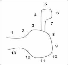
If in the case of a small Cul-de-Sac if first property on the right hand dominates the street entrance, number from there:
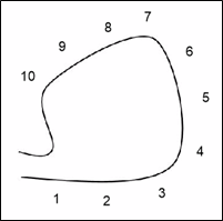
In a large Cul-de-Sac the split between odd and even is at the head of the Cul-de-Sac:

If a Cul-de-Sac development is restricted to only one side of the road. Number consecutively.
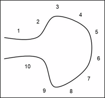
In the case of offset properties normally at 90° to the main street, number properties outward from road:
-
For infill numbering, all available numbers will be used first with letters being applied if necessary. Avoid using letters beyond ‘C’
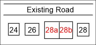
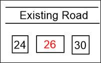
A single plot of infill follows the existing numbering scheme but with the ‘a’ suffix attached to the lowest adjacent number within the existing scheme.
If multiple infill plots, follow existing numbering scheme but with the a, b, c suffix attached to the lowest adjacent number within the existing scheme.
If 2 properties are merged into one, the numbering scheme will be in consultation with the owner/developer. The preferred option is the lowest of the old numbers.
-
Existing numbering
-
Merged properties
If in rural location, consider existing numbers of adjacent streets.
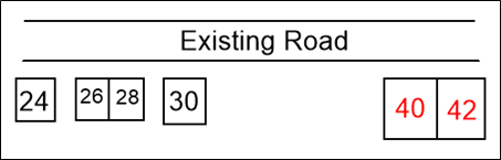
If dealing with a development that falls between a large number sequence gap. Do not use lowest number. Try to retain suitable numbers either side for future use.
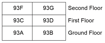
- Flats are numbered from the ground floor upwards using number and letter.
Where there are more than two flats on a floor, these are numbered clockwise. Number properties against the street that the front door entrances onto. Avoid the use of ‘FLAT’ where possible.
- These features should not be included in the numbering scheme.
- Garages
- Car Ports
- Underpasses
- Car Parks spaces
- Sub Station
- Existing properties shown on plan
- Commercial Units
Should the Street Numbering Officer require further clarification the matter shall be referred to their immediate line manager for resolution.
6. House names
- Naming of properties will follow the guidelines set out for naming of street name prefixes (see section 5 i–x)
- Names which duplicate, in full or in part, names on nearby properties will not be accepted.
- Names which duplicate in full or in part, the name of a nearby street name will be reviewed.
7. Completion
Once the draft scheme has been completed the Street Numbering Officer will issue an official notification containing a letter and location plan using the following rules.
- Rotate the plan to North prior to annotation
- Use black ink
- Scribe numbers onto plan
- Colour code the number against the street name
- For flats include separate key of positions
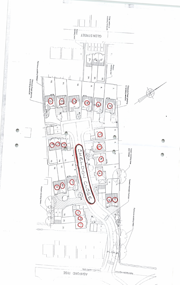
Example of a street numbering plan
8. Distribution of notification (charge applied)
Once a new street numbering scheme has been confirmed and the relevant fee paid, notification needs to be sent to the authorities and organisations listed below (see Appendix A).
9. Re-naming or re-numbering
There are occasions where existing naming and numbering is found to be unsatisfactory and changes need to be made, Complaints come from many sources and all should be properly investigated before deciding on a course of action.
If it is decided that renaming/numbering is necessary, the essential services should first be proposal and consultation.
It is then necessary to seek observations from all persons who are residents or owners of the properties being renumbered by a renaming and renumbering proposal. This is best achieved by the Public Display of an Official Notice in the area to be affected, and by writing to affected occupiers.
Following the expiry of a reasonable time (suggest 28 days), a decision is reached taking into account objections and other observations received.
A positive response to change is required from two-thirds of land/property owners & tenants to confirm the change unless there are other extenuating circumstances.
A charge is often applicable
- link: Schedule of charges.
10. Enforcement
On occasion, it is necessary to consider enforcement action to ensure the display of correct names and numbers. Informal action should in all cases be tried first. If however, persuasion fails to achieve results we will consider taking enforcement action.
11. Record keeping
All requests are recorded in Outlook, under a shared inbox. All correspondence and contact concerning the request is also saved. This allows the function to continue during leave or absence.
Once completed a paper copy of the notification letter and plan is printed and filed in the SNAN files along with all associated paperwork.
A pdf copy the notification letter and plan, along with all associated electronic correspondence, is then filed in P drive on the IT network.
Organisations the Council inform of new or changed addresses:
Externally:
- Royal Mail Address Development Team
- Nottinghamshire Police
- Nottinghamshire Fire and Rescue
- East Midlands Ambulance Service
- Nottinghamshire County Council LSG
- Valuation Office Agency
- Land Registry Nottingham Office
- Central Networks
- Severn Trent
- British Telecom
- NLPG Hub
Internally:
- LLPG Custodian
- Land Charges Section
- Council Tax Billing
- Development Control
- Building Control
- Elections Officer
- Waste Management
- Highways Services
- Legal Section
- Environmental Health
- Customer Services
No charge is levied against these bodies for receiving the postal address information.
Contact details
- Street naming and numbering
- Contact street naming and numbering
- lpg@ashfield.gov.uk
- 01623 457281
-
Ashfield District Council
Council Offices
Urban Road
Kirkby in Ashfield
Nottinghamshire
NG17 8DA
Page last updated 24 March 2026